Maps
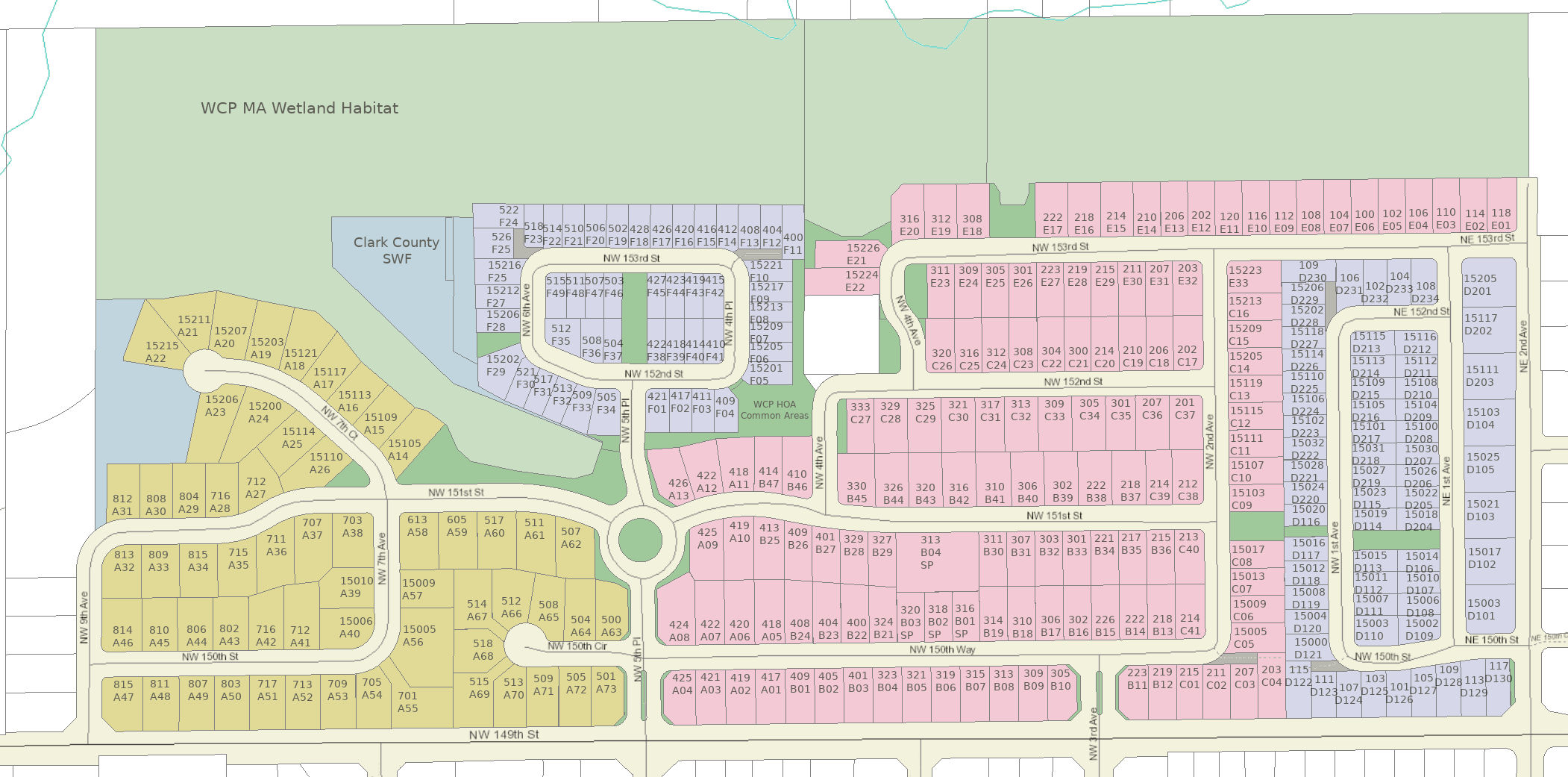
Whipple Creek Place HOA is a community located in Salmon Creek, Washington a suburb of Vancouver. The property extends from NE 2nd Avenue west to NW 9th Court, and from NE 149th Street north to 153rd Street. Our U.S. Postal Zip Code is 98685.
The HOA is comprised of 310 lots, all designated as single family homes. Home construction began in 2003 and was completed in 2007. The development was built in seven (7) Phases, hence the abbreviated description of each lot in Clark County records refers to the Phase Plat it was located in. Each Phase, A, B, C, D1, D2, E, and F had its own set of CC&Rs. In 2005, when the developer turned the property over to the HOA, the Membership voted to consolidate the seven (7) platted Phases into three (3) Sub-Associations, Sub-Association 1 2 and 3 for administrative purposes . Again, in 2024, the Membership voted to consolidate the three Sub-Associations into one HOA, the Whipple Creek Creek Place Homeowners Association, to cut costs and bring the CC&Rs into compliance with new WA state statutes. Each consolidation is shown on the map below.
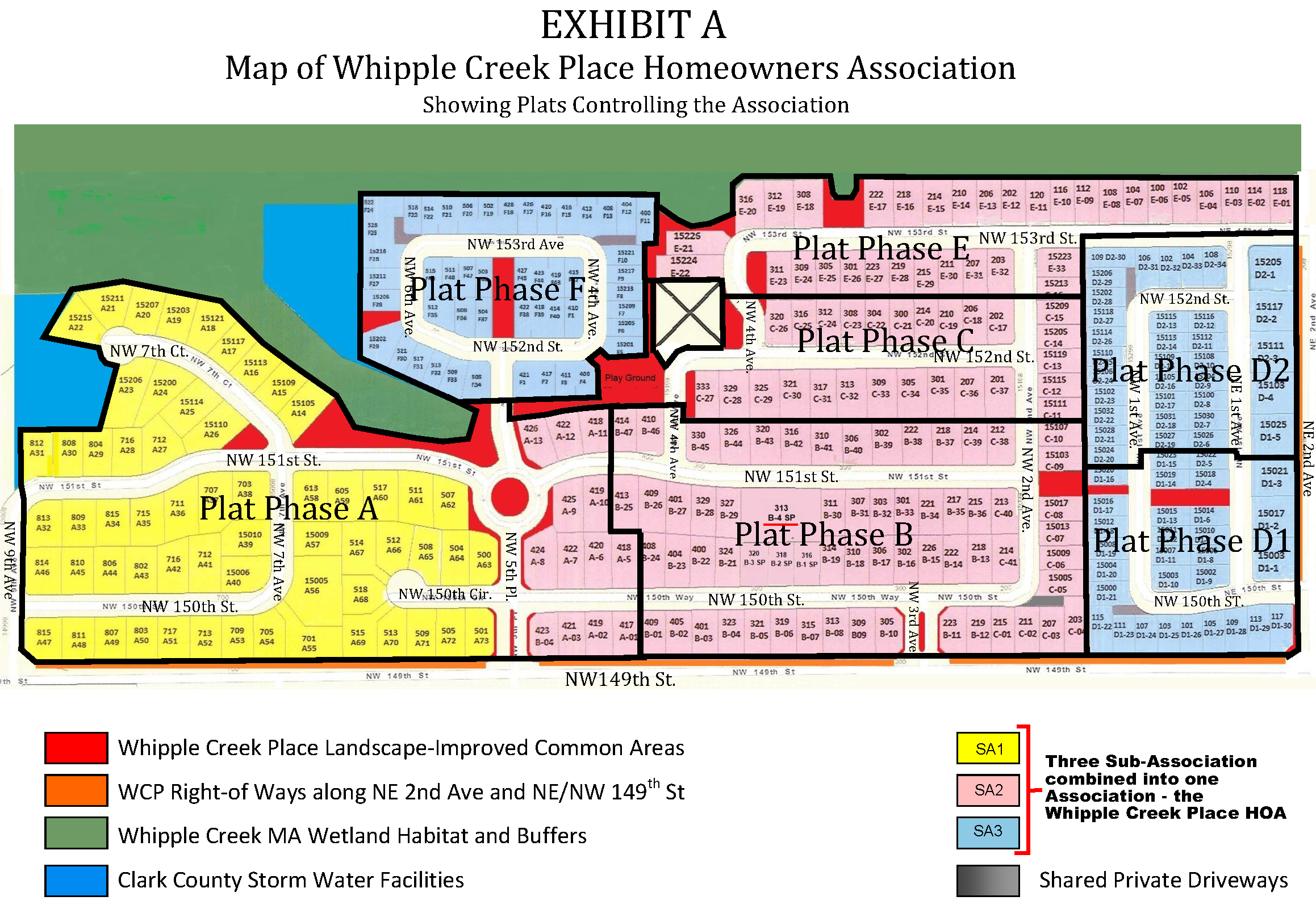
The seven (7) Phase Plats as recorded in Clark County records will always remain in effect and will be referred to in various Association matters.
- Phase A – 73 lots
- Phase B – 50 lots
- Phase C – 41 lots
- Phase D1 – 30 lots
- Phase D2 – 34 lots
- Phase E – 33 lots
- Phase F – 49 lots
The address placement and orientation on all maps facilitates the wonderful work of our volunteers who distribute occasional Association fliers and newsletters. In map areas where it´s helpful, the address number FACES the street that the WCP home FACES. So it´s from the perspective of a volunteer walking down that street. Try it out! It actually makes the areas less confusing for door-to-door delivery.
Help your neighborhood Association – it will be greatly appreciated! To VOLUNTEER for flier distribution please contact any member of YOUR BOARD or our management company. Get fresh air, good exercise and a chance to know your neighborhood a little better. THANKS!
We want to keep these maps updated and accurate. We encourage residents to report suggestions or need for changes or corrections.
Click on each map name to VIEW and/or PRINT a pdf or image file:
- County Map of WCP, Color Coded for Sub-Association
- Volunteer Distribution Map 310 Lots WCP
- Address Map 310 Lots WCP
- ALL 7 PHASES Map 310 Lots
- 3 Sub-Associations Map310 Lots WCP
- Phase A Map 73 Lots WCP
- Phase A ENLARGED WCP
- Phase B Map 50 Lots WCP
- Phase B ENLARGED WCP
- Phase C Map 41 Lots WCP
- Phase C ENLARGE WCP
- Phase D1 Map 30 Lots WCP
- Phase D1 ENLARGE WCP
- Phase D2 Map 34 Lots WCP
- Phase D2 ENLARGED WCP
- Phase E Map 33 Lots WCP
- Phase E ENLARGE WCP
- Phase F Map 49 Lots WCP
- Phase F ENLARGE WCP
Irrigation System Maps by RWH Fall 2021
- WCP HOA Master Irrigation Zone Map Locations
- Zone Map 1 – NW 5th Pl Entrance to NW 7th Ct
- Zone Map 1 – NW 5h Head Description and Watering Times Fall 2021
- Zone Map 2 – Phase F Path and SWF Access
- Zone Map 2 – Phase F Head Description and Watering Times Fall 2021
- Zone Map 3 – Playground and Paths
- Zone Map 3 – Playground & Paths Head Descriptions & Watering Times Fall 2021
- Zone Map 4 – NW 4th Ave between NW 151st and 153rd St
- Zone Map 4 – NW 4th Ave Head Descriptions & Watering Times – Fall 2021
- Zone Map 5 – Paths between NW 2nd Ave and NE 1st Ave
- Zone Map 5 – Paths NW 2nd to NE1st Head Descriptions & Watering Times – Fall 2021
- Zone Map 6 – NE 2nd & NW3rd Entrances, 300 NW 153 St Common Area
- Zone Map 6 – NE2 to NW3, 300 NE 153rd – Head Descriptions Watering Times -Fall 2021
- Map – WCP Water Meter, Controller and Valve Map
- WCPHOA Water and Electric Meters
- 2016 thru 2021 Water Bill Summary